
When you are dropped onto an unmarked dirt road under an empty sky, staring at a hazy line of scrubland, the entire planet feels like a completely impossible guessing game. But the world’s elite competitive geography players do not memorize millions of kilometers of random highway. Instead, they think like forensic detectives.
Every single Street View frame is packed with standardized human engineering, municipal safety codes, and unmistakable environmental markers. Sovereign highway administrations do not invent guardrail posts, utility poles, or road paint from thin air; they follow national safety doctrines, historical treaties, and continental procurement contracts. Once you learn to look past the generic scenery and focus on the standardized hardware, an anonymous country road quickly reveals its exact nationality.
“The rookie looks at the trees and guesses a continent. The master looks at the reflective tape on the delineator post, the hole pattern in the utility pole, and pins the country within three seconds.”
Here is the exhaustive, definitive guide to reading roadside clues across every major region of the world.
1. The Five-Second Scan: How Champions Deconstruct a Round
When a round begins in competitive play, the ticking countdown timer creates immediate psychological pressure. Panicking players spin their view frantically in full circles hoping to spot a bilingual town sign that may never appear.
Champion players, by contrast, execute a calm, disciplined mental scan routine that filters the world systematically from general geography down to specific borders:
Step One: Look Down at the Tarmac and the Vehicle
Before looking at the horizon, glance down directly at the car and the road surface beneath you. What generation camera was used? Is there a noticeable circular blur or magenta chromatic aberration, or is the image ultra-sharp HDR? Is there a roof rack visible in the camera's blind spot? Most importantly, which side of the center line is the vehicle traveling on?
Step Two: Inspect the Paint and Road Marking Geometry
Is the centerline white or bright yellow? Are the outer road edges painted with solid continuous lines, or are they marked with broken dashes? Road line paint is one of the most reliable international standards on Earth. A yellow centerline instantly rules out 90% of Europe, while dashed outer shoulder lines immediately point toward Scandinavia.
Step Three: Scan the Shoulders for Delineators and Poles
Look along the roadside verges for bollards—the reflective guideposts installed for nighttime driving safety. Note their color, the shape of their reflective caps, and whether they stand on both sides of the tarmac. Next, look up at the electrical distribution poles. Are they made of solid timber, circular concrete, or do they have distinctive rectangular holes cut through the center?
Step Four: Read the Solar Compass
Orient your view directly toward the digital North marker on your compass. If the sun is sitting in the northern half of the sky, you are locked into the Southern Hemisphere. If the sun is in the southern half of the sky, you are in the Northern Hemisphere. This single check prevents costly blunders between Australia and Europe, or South Africa and the Mediterranean.
Step Five: Examine the Peripheral Nuances
Finally, look at the cultural artifacts: the color and aspect ratio of blurred license plates on passing traffic, the presence of bilingual directional signs, architectural roofing styles (terracotta tile versus corrugated steel), and the soil color visible in roadside ditches. By the time five seconds have elapsed, you should have narrowed the entire planet down to one or two likely candidates.
2. The Great Divide: Left vs. Right Driving Territories
Driving side is the single most powerful filter in Street View. Out of roughly 195 sovereign nations and territories mapped by Google, only 76 territories drive on the left. When traffic moves on the left, you can instantly eliminate about 70% of the entire landmass of the Earth.
The Major Left-Hand Driving Havens
Left-hand traffic is heavily concentrated in specific historical and regional clusters:
The British Isles & Mediterranean Outposts: The United Kingdom, Ireland, the Isle of Man, Jersey, Guernsey, Malta, and Cyprus all drive on the left. If you see European architecture or English signage combined with left-hand traffic, your search space is remarkably narrow.
Southern & Eastern Africa: A contiguous belt of African nations drives on the left: South Africa, Botswana, Eswatini, Lesotho, Namibia, Kenya, Uganda, Tanzania, Zambia, Zimbabwe, Mozambique, and Malawi. (By contrast, West African coverage in Nigeria, Ghana, and Senegal drives on the right).
The Asia-Pacific Corridor: Japan, Australia, New Zealand, Thailand, Malaysia, Singapore, Indonesia, India, Bangladesh, Sri Lanka, and Bhutan drive on the left. In this corridor, driving side is invaluable for distinguishing lookalikes—for instance, Thailand drives on the left with yellow centerlines, whereas neighboring Cambodia drives on the right.
The Americas Outliers: While North and South America drive overwhelmingly on the right, left-hand traffic survives in a handful of Caribbean island nations (Jamaica, Bahamas, Barbados, Trinidad & Tobago) and two South American mainland nations: Guyana and Suriname.
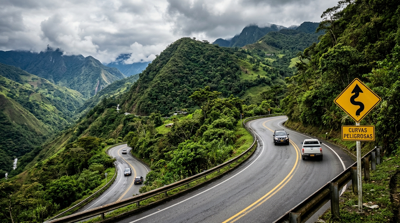
How to Confirm Driving Side on an Empty Highway
What if you spawn on a rural highway with zero moving traffic in either direction? You can still establish the driving side in seconds by observing three subtle physical clues:
1. Parked Cars: In almost every country in the world, vehicles park facing the legal direction of travel on their side of the curb. A single parked pickup or sedan in front of a farmhouse reveals which side traffic belongs on.
2. Traffic Sign Orientation: Warning signs, speed limits, and intersection notices are angled toward oncoming traffic. If the signs along your shoulder are facing directly toward you, you are traveling on the correct legal side of the road.
3. Road Surface Merge Lines: Painted white arrows on highway entry slips and turning pockets point in the direction vehicles are traveling, offering unmistakable evidence even in desolate desert environments.
3. The Silent Sentinels: A Field Guide to Roadside Bollards
Road bollards—often called delineator posts or guideposts—are small roadside markers planted along road shoulders to demarcate the edge of the pavement at night. Because road maintenance and highway safety are strictly managed at the national level, bollard designs are heavily standardized within borders and rarely shared identically across them.
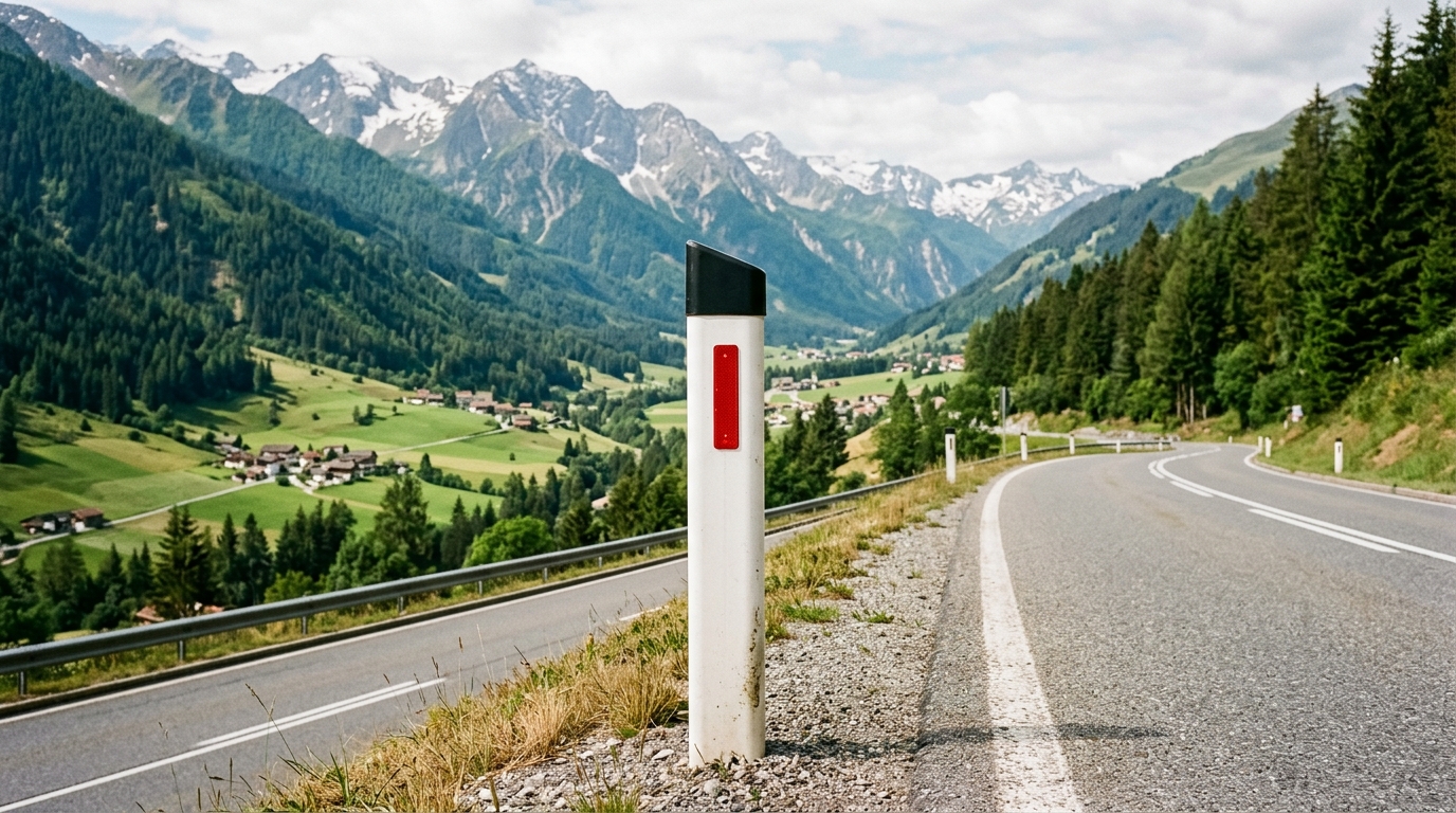
To read a bollard properly, examine three physical attributes: the overall shape and color of the post body, the color of the protective cap at the top, and the shape, color, and placement of the reflective insert.
Austria: The Angled Black Crown
Austrian bollards are among the most famous and recognizable in the entire geography guessing community. The post is sleek white with a gently curved profile. The distinguishing hallmark is a crisp, angled black cap that slopes downward toward the road. Embedded directly in the front face of this black cap is a narrow, vertical red reflector strip. On the rear face, visible when looking backward, sits a corresponding white reflector. Seeing this post in mountainous or alpine valleys confirms Austria almost instantaneously.
France: The Clean Red-Collared Cylinder
French highways use a remarkably minimalist design. The bollard is a clean white cylinder of uniform thickness from top to bottom. Instead of a black cap, it features a single reflective red band wrapped neatly around the upper collar of the post. In snowy alpine passes or near the Pyrenees, road crews often swap these for tall yellow-and-black wooden snow stakes, but on normal French departmental roads, the white post with the red ring is king.
Denmark: The Short Slanted Dwarf
Danish bollards stand noticeably shorter than their German or Swedish neighbors. They consist of a stout white post topped with an angled yellow head that houses a small, rectangular amber reflector. Because Denmark is uniformly flat and heavily agricultural, spotting these short, stubby yellow-capped posts among vast fields of rapeseed or coastal dunes is an immediate geographical lock.
Sweden & Finland: The Nordic Reflector Duel
Scandinavia offers subtle, high-level distinctions between neighboring nations. Swedish delineator posts are white rectangular columns sporting a thick black band near the top, within which sits a small white or pale amber rectangular reflector.
Finland, by contrast, uses a white post with an angled, slanted top and an unmistakable, vibrant vertical orange-red reflector on the front face, with a white reflector on the rear. When you are traveling through endless Scandinavian pine and birch forests, this bright orange reflector tells you immediately that you have crossed into Finland rather than Sweden.
Iceland: The Volcanic Yellow Pillar
Iceland’s delineator posts are virtually impossible to confuse with anything else on Earth. They are tall, bright yellow plastic cylindrical posts with a small reflective patch near the top. Set against Iceland's stark, treeless landscape of jet-black volcanic basalt, green moss, and icy glacial fjords, these bright yellow posts shine like beacons.
Poland: The Red Diagonal Slash
Polish delineator posts are white rectangular posts with a distinctive red band that wraps around the post at an angle, like a diagonal sash. A small vertical reflector is mounted inside the red band. On sharp turns or hazardous intersections, Polish road authorities frequently deploy rounded cylindrical bollards painted with thick, alternating red-and-white horizontal safety stripes.
Australia & New Zealand: The Red Band Nuance
Both Australia and New Zealand drive on the left and feature white guideposts along rural highways. But their reflective markings are distinct. Australian guideposts are white rectangular posts with a red rectangular reflector on the left side of the road and a white reflector on the right. In New Zealand, rural guideposts feature a continuous red reflective band that wraps completely around the post, creating an unbroken ring of red.
Russia: The Black-Bottom Base
Russian bollards follow a classic Eastern European safety standard: a white rectangular post topped with an angled face containing a red or orange vertical reflector, but with the bottom 20 to 30 centimeters painted solid black. This black base provides visual contrast when heavy snow blankets the road verges in winter.
4. Utility Pole Anatomy: Concrete Perforations and Wirecraft
When a panorama drops you onto a flat road with zero bollards, look upward toward the power lines. Electrical distribution infrastructure represents colossal municipal investments that remain in place for decades. Different nations construct their utility poles out of different materials and with different structural engineering signatures.
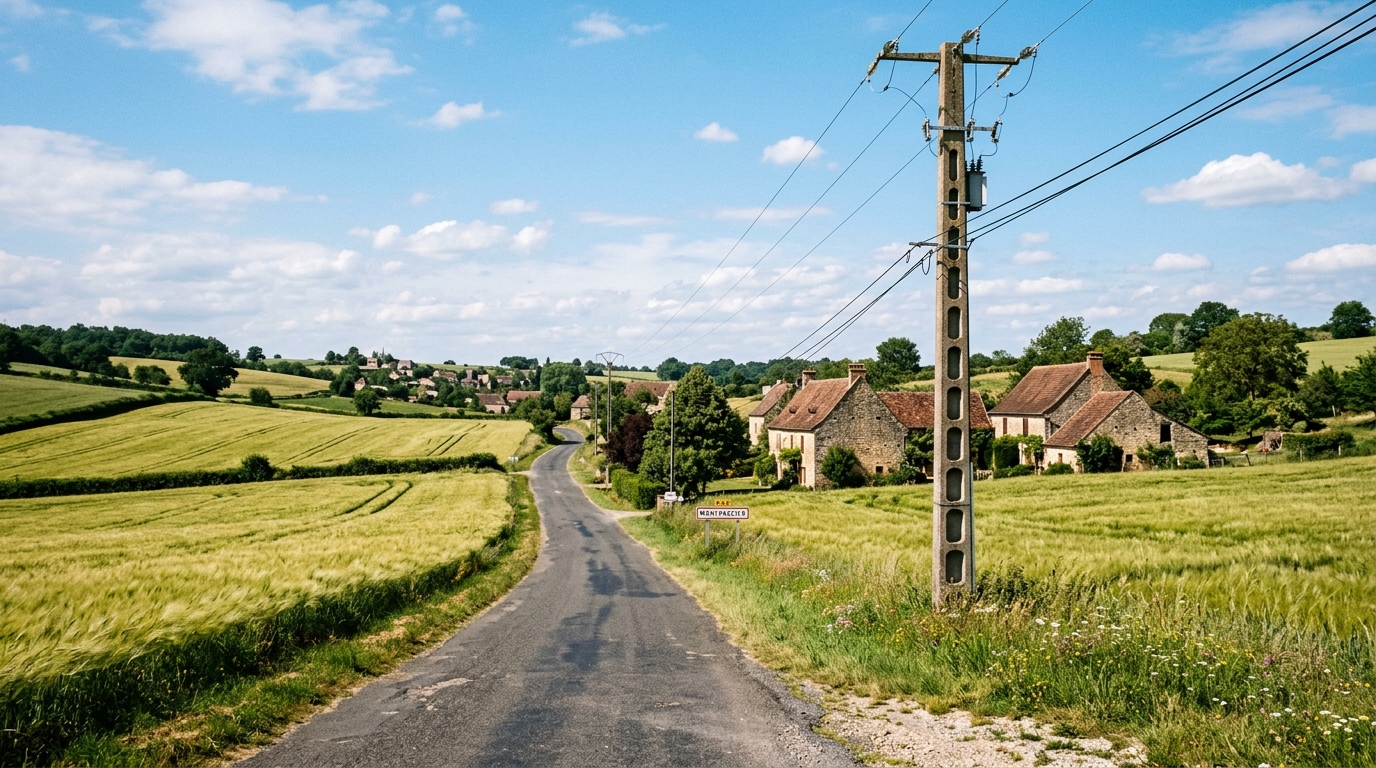
The French Holey Pole vs. The Polish Perforated Post
One of the most celebrated clues in geography detective circles is the French “holey pole.” In France, rural electricity poles are commonly cast from reinforced prestressed concrete with a vertical column of hollow rectangular cutouts passing completely through the shaft. These cutouts reduce weight, cut concrete costs, and allow cross-winds to pass through during winter storms. If you see concrete poles with clean rectangular ladder-like holes, you are in France or a French territory.
Poland employs a similar concrete casting concept, but with a crucial geometrical difference: Polish concrete poles feature circular holes running vertically up the shaft. Circular perforations indicate Poland, Romania, or the Baltic states; rectangular perforations almost always indicate France.
Spanish Ladder Rungs and Portuguese Crossarms
In Spain, concrete utility poles frequently feature built-in metal step irons (ladder rungs) bolted directly into one side of the pole, forming an open ladder for utility workers to climb without needing a crane bucket truck.
In neighboring Portugal, utility poles are often accompanied by horizontal steel crossarms holding small white porcelain insulators. Portuguese roads are further confirmed by the ubiquitous presence of rounded blue-and-white roadside kilometer stones nestled into the gravel shoulder.
Latin American Concrete Architecture: Mexico, Brazil, and Chile
Latin America features distinctive utility pole signatures that allow you to distinguish its three largest countries effortlessly:
Mexico: Utilities use octagonal concrete poles that often feature small rectangular slots, commonly mounted alongside Mexican Federal highway shields (white crests with green route numbers).
Brazil: Brazilian electrical distribution utilizes square concrete poles with rounded corners, topped with heavy cylindrical transformers mounted high near the crossarms. Furthermore, Brazilian road signs are almost universally backed with black paint or black metal sheeting.
Chile: Chilean roads use sturdy concrete poles with round perforations similar to Mexican poles, but the surrounding flora—such as poplars, weeping willows, and dry central valley vineyards—along with Chilean white-and-red highway signs immediately distinguishes them.
East Asian Warning Wraps: Japan vs. Taiwan
In East Asia, electrical utilities protect their infrastructure from typhoons, earthquakes, and vehicle impacts using colorful reflective base wraps:
Japan: Circular concrete poles with metal climbing step bolts spiraling upward, fitted with bright yellow-and-black spiral protective plastic sleeves wrapped around the bottom six feet of the shaft.
Taiwan: Concrete poles featuring bold, alternating black-and-yellow diagonal hazard stripes painted directly onto the concrete base itself.
5. Road Line Physics: The Vienna Convention vs. The American MUTCD
The paint on the road is not chosen randomly by highway contractors. It is strictly dictated by international treaties and continental civil engineering standards.
The Vienna Convention: Europe's White Centerline Doctrine
Adopted in 1968, the Vienna Convention on Road Signs and Signals standardized road safety markings across Europe. Under this convention, all dividing centerlines are white. Whether you are driving through the vineyards of Bordeaux, the motorways of Germany, or the rolling plains of Poland, the line separating opposing traffic lanes is universally white.
The Notable Exception: Norway is the great European outlier. While the rest of continental Europe uses white centerlines, Norway utilizes a bright yellow centerline combined with white dashed outer shoulder lines. If you see dramatic Nordic fjords and pine forests with a bright yellow centerline, you are in Norway, not Sweden.
The MUTCD Standard: The Yellow Centerlines of the Americas
In the Western Hemisphere, nations follow the Manual on Uniform Traffic Control Devices (MUTCD). Under this standard, yellow is strictly reserved for dividing traffic moving in opposite directions. A solid or dashed yellow line in the center of the road is the universal hallmark of the United States, Canada, Mexico, Brazil, Colombia, Argentina, and Chile. Outside the Americas, yellow centerlines also appear across Japan, Taiwan, and South Africa.
The Secret of the Outer Shoulder Dashes
What about the outer edge lines along the shoulder? Here lies one of the most powerful tiebreakers in Scandinavia:
Sweden: Features distinctive, widely spaced white dashed lines running continuously along the outer edge of the pavement.
Finland: Uses solid, continuous white lines along the outer road edge. Both countries have identical red wooden farmsteads and silver birch trees, but glancing down at the shoulder dashes settles the debate instantly.
South Africa & Botswana: These Southern African nations use yellow paint on the outer shoulder edge of the road, reserving white paint for the centerlines. This yellow emergency shoulder is an iconic southern African trademark.
6. License Plate Forensics: Decoding the Privacy Blur
Google’s automated image processing algorithms blur license plate numbers and registration letters to comply with international privacy regulations. However, the blurring algorithm does not erase the plate's aspect ratio, background color, or outer colored registration strips.
The European Union: Blue Strips and Outliers
Across the 27 member states of the European Union, passenger vehicles feature an elongated horizontal white plate with a single vertical blue strip on the left-hand edge containing the European circle of stars.
The Double Blue Strip Outliers: Two European countries feature a distinctive double blue strip—a vertical blue band on both the left and right edges of the license plate. If you see a blurred white plate with blue stripes on both ends, you are in Italy or Albania.
The Yellow License Plate Nations
While most of the world uses white plates, yellow license plates are heavily concentrated in a few specific countries:
The Netherlands & Luxembourg: Private passenger vehicles feature bright yellow reflective plates on both the front and rear bumpers.
The United Kingdom: British vehicles feature a unique two-tone registration system: clean white plates on the front bumper and bright yellow plates on the rear bumper.
Israel: Vehicles use bright yellow plates on both the front and rear, frequently paired with yellow roadside curb markings and Hebrew signage.
The Mercosur Standard: South America's Blue Header
In South America, member nations of the Mercosur economic trade bloc (Argentina, Brazil, Uruguay, and Paraguay) adopted a unified license plate standard in 2016. These plates feature a distinctive horizontal blue band across the very top of the plate with the national flag in the corner and black lettering below on a white field.
7. Vehicle Hardware & Camera Generation Artifacts
When mapping developing, remote, or wilderness geographies, Google did not deploy standard passenger sedans. They contracted local commercial four-wheel-drive trucks, safari expedition vehicles, and custom camera mounts. The physical hardware attached to the vehicle created unmistakable “meta” artifacts in the imagery.
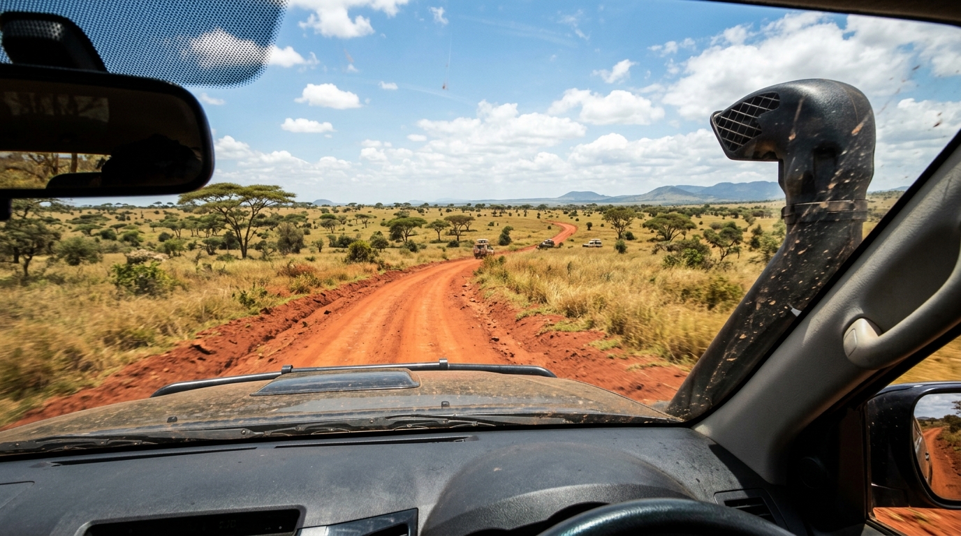
The Famous Vehicle Hardware Tell-Tale Signs
The Kenya Snorkel: To protect truck engines from ingesting fine red volcanic dust across the Great Rift Valley, the Google camera pickup in Kenya was fitted with a raised black plastic air intake snorkel on the front-right fender. Seeing this snorkel in your lower view locks your guess into Kenya.
The Ghana Roof Tape: In Ghana, the camera was mounted to a black tubular roof rack with a thick, noticeable piece of black electrical tape wrapped tightly around the front-right crossbar.
The Senegal Sky Rift:In Senegal, the camera car features black metal roof bars with silver mounting clips. Furthermore, older Senegalese coverage suffers from a famous software stitching defect: a vertical tear or seam in the sky and clouds affectionately known as the “sky rift.”
The Nigeria Police Escort: In Nigeria, government regulations required an armed police security vehicle to follow the Google Street View vehicle. In almost all Nigerian highway coverage, looking into the rear view reveals a white Toyota Hilux pickup with a flashing red and blue police light bar following closely behind.
The Mongolia Expedition Rack: Mongolian rural coverage was captured using rugged off-road trucks fitted with massive roof racks stacked with camping gear, blue luggage tarps, and spare tires strapped down to survive the trackless steppe.
Camera Generations: From Gen 1 Blur to Gen 4 HDR
Google has upgraded its panoramic camera technology across four distinct generations over nearly two decades:
Gen 1 (2007–2008): Extremely low resolution (sub-720p), heavy blur, and circular dark vignetting in the four corners of the frame. Today, Gen 1 coverage is rare, found mostly in older, un-updated residential areas of the United States and Australia.
Gen 2 (2008–2011): Characterized by a large circular blur on the vehicle roof, softer overall image sharpness, and prominent purple/magenta chromatic fringing around high-contrast tree branches against bright skies. Gen 2 is common in rural Russia, Brazil, and southern Africa.
Gen 3 (2011–2017): Crisp, natural 1080p resolution with realistic color balance. A hallmark clue of Gen 3 imagery is a thin, flexible metal radio antenna frequently visible in the lower rear-right mirror.
Gen 4 (2018–Present): Ultra-vibrant High Dynamic Range (HDR) photography. Gen 4 features razor-sharp edge contrast, brilliant blue skies, deep shadows with preserved detail, and zero visible antenna.
8. Celestial Alignment, Soil Chemistry, and Indicator Trees
When human engineering is entirely absent—when you spawn on an unmarked dirt track with no poles, no bollards, and no visible car—you must turn to natural science.
The Solar Compass Formula
The compass in your top-left interface points toward magnetic North. Find the sun in the sky and note its position:
The Sun in the Northern Sky: You are physically located in the Southern Hemisphere. This immediately eliminates Europe, the United States, Canada, Russia, and northern Asia. Your options collapse to Australia, New Zealand, southern Africa, and the southern half of South America.
The Sun in the Southern Sky: You are in the Northern Hemisphere.
The Equatorial Zenith: If the sun is positioned directly overhead at an 85° to 90° angle—casting almost zero directional shadow beneath vehicles—you are within 5 degrees of the equator (Colombia, Ecuador, Uganda, Kenya, or Indonesia).
Soil Chemistry and Indicator Flora
Laterite (Deep Red Clay Soil): Rich in oxidized iron and aluminum, vivid red dirt is a hallmark of intense tropical weathering. Seeing brilliant red soil roads heavily favors interior Brazil (Goiás, Minas Gerais), central Uganda, southern Senegal, Cambodia, and the red interior of Australia.
Silver Birch (Betula pendula): Slender white tree trunks with horizontal black lenticel bands. Birch forests thrive in the cool boreal zones of European Russia, Finland, Sweden, Estonia, and Latvia.
Paraná Pine (Araucaria angustifolia): A striking, ancient umbrella-shaped conifer with flat, circular crown canopies. Wild Paraná Pines grow almost exclusively in the elevated highlands of Southern Brazil (Paraná and Santa Catarina) and neighboring Misiones in Argentina.
9. The Great Lookalike Duels: Disambiguating Sibling Nations
Championship geography matches are decided on lookalike pairs—countries that share identical climates, languages, or terrain. Here is how expert players break the ties in split-second decisions:
Sweden vs. Finland: The Forest Twin
Both feature endless pine and birch taiga, red wooden houses, and similar granite outcroppings.
The Tiebreaker: Look down at the road shoulder. Sweden uses long dashed white lines on the outer road edges; Finland uses solid continuous white lines. In addition, Swedish roadside warning signs have bright yellow centers, whereas Finnish warning signs use an unmistakable orange-tinted background.
Australia vs. South Africa: The Southern Red Earth
Both drive on the left, have the sun in the North, feature dry red soil, and have native or imported eucalyptus trees.
The Tiebreaker: Look at the road shoulder line. South Africa features a continuous yellow line on the outer left edge of the road. Australia uses white outer edge lines and white rectangular guideposts with red reflectors on the left and white on the right.
Colombia vs. Mexico: The Mountain Tarmac
Both are mountainous Spanish-speaking nations that use yellow centerlines.
The Tiebreaker: Look at the rear of road signs. In Colombia, road signs are reinforced with a distinctive metal cross-brace (an “X” pattern) bolted to the back. In Mexico, sign backs are plain galvanized steel, and utility poles are octagonal rather than round.
10. Frequently Asked Questions
What is the most reliable first clue to check in Street View?
The single most decisive first clue is the driving side. Only 76 nations and territories drive on the left, while over 160 drive on the right. Checking the orientation of road signs, parked vehicles, and road line merges cuts the possible global map in half within one second.
How do you tell what hemisphere you are in using the sun?
Orient your digital compass directly North. If the sun is located in the northern sky, you are in the Southern Hemisphere (e.g., South Africa, Australia, New Zealand, Argentina, Chile). If the sun is in the southern sky, you are in the Northern Hemisphere. If the sun is directly overhead, you are in the equatorial tropics.
What is a French holey pole in geography guessing games?
A French holey pole is a reinforced concrete utility pole featuring a vertical column of rectangular perforations (cutout holes) passing all the way through the shaft. Similar concrete holey poles appear in Poland with round holes, and in Mexico with octagonal cross-sections.
Why do some Street View cars have a snorkel on the side?
A black plastic raised air intake (snorkel) attached to the front-right fender of the camera vehicle is the iconic signature of Google coverage in Kenya. It was installed to navigate dusty, unpaved savanna trails without choking the engine.
How do you distinguish Sweden from Finland in Street View?
Inspect the outer road edge lines. Sweden uses broken white dashed lines with long gaps on the outer road edges, whereas Finland uses solid white outer lines. Furthermore, Swedish warning signs feature yellow backgrounds with red borders, while Finnish warning signs use orange or yellowish-orange reflective backing with distinct font kerning.
Which countries have yellow centerlines on their roads?
Yellow road centerlines follow the American MUTCD engineering standard and are ubiquitous across the United States, Canada, Mexico, Brazil, Colombia, Chile, and Japan. Continental Europe almost universally uses white centerlines under the Vienna Convention, with Norway being a notable hybrid outlier using yellow centerlines.
Continue Learning
Test Your Forensic Clues in Real Rounds
Join thousands of geography detectives sharpening their mental checklists in real-time 1v1 duels, daily streak challenges, and free exploration on LostStreet.
Play LostStreet Free Now →