1. Geographical & Map Formation
Belize is located on the eastern Caribbean coast of Central America, bordered by Mexico and Guatemala. The country's borders emerged from 18th-century treaties between Great Britain and Spain. British logwood cutters, known as Baymen, established settlements along the coast, and treaties defined limits for timber extraction. The southern border along the Sarstoon River was formalized by the Wyke-Martin Treaty of 1859 between Britain and Guatemala. However, Guatemala later renounced the treaty, claiming the southern half of Belize, creating a territorial dispute that delayed Belize's path to independence for decades.
2. Heraldry & Flag Symbolism
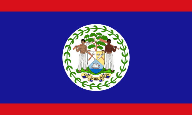
Adopted on September 21, 1981, the flag of Belize features a royal blue field with a thin red horizontal stripe at the top and bottom, charged with the national coat of arms on a central white disc. The coat of arms depicts two woodcutters (one Mestizo, one of African descent) holding logging tools next to a mahogany tree, reflecting the country's multi-ethnic population and its historical reliance on the forestry industry. The red stripes were added at independence to represent the opposition party, symbolizing national unity.
3. Path to Freedom & Sovereignty
Formerly known as British Honduras, the colony gained self-governance in 1964 and changed its name to Belize in 1973. Led by George Cadle Price, the country actively campaigned for sovereignty at the United Nations. Belize achieved full independence from the United Kingdom on September 21, 1981. However, due to Guatemalan invasion threats, British troops remained in Belize for years after independence to guarantee its security until relations improved.
Key Historical Milestones
British settlers defeat a Spanish naval force at the Battle of St. George's Caye, securing control.
The Anglo-Guatemalan Treaty defines the borders of British Honduras.
Belmopan is established as the new inland capital after Hurricane Hattie devastates Belize City.
Belize achieves full independence from the United Kingdom on September 21.
Belizeans vote in a referendum to refer the Guatemalan border dispute to the International Court of Justice.
4. Modern Geopolitical Challenges
Belize faces difficulties from natural disasters and economic vulnerabilities. The country lies in the Caribbean hurricane corridor, requiring the capital to be moved inland from Belize City to Belmopan in 1970 following Hurricane Hattie. The nation also struggles with high public debt, high youth unemployment, and an ongoing border claim by Guatemala, which was referred to the International Court of Justice in 2019 for final resolution.
Frequently Asked Questions
Why did Belize change its name from British Honduras?
The name was changed to Belize in 1973 as a step toward independence, asserting a local identity separate from British colonial rule.
What is unique about the two woodcutters on the Belize flag?
The flag depicts two woodcutters of different racial backgrounds (Mestizo and Afro-Belizean) to represent the country's diverse, multi-ethnic population.
Think You Can Pin Belize on the Map?
Use the landscape and flag clues you just learned to spot this country in our free Street View guessing game.
Play LostStreet Guessing Game